Log in
All resources
Create a design
9,486 Free Artworks of Collections Of The Bibliothèque Nationale De France
chorographia britanniae (1741-1742)
maps by willem and johannes blaeu
guillaume sanson
lucas janszoon waghenaer
context files from gallica
philippe de la rué
illustrations of jean de la fontaine's fables by jean-baptiste oudry
engraving
high renaissance
rome in the 1550s
bibliothèque nationale de france
johannes le francq van berkhey
1730s maps of the philippines
baroque painting
map of ancient assyria by philippe de la rué
bibliothèque nationale de france
18th-century maps of the caspian sea
claude auguste berey
illustrations of jean de la fontaine's fables by jean-baptiste oudry
claude olivier gallimard
illustrations of jean de la fontaine's fables by jean-baptiste oudry
pierre etienne moitte
illustrations of jean de la fontaine's fables by jean-baptiste oudry
a.-j. de fehrt
old maps of regensburg
baroque
1750s maps of california
1705 maps of california
16th-century maps of lisbon
1580s maps of portugal
andalusia in the 1590s
1590s maps of spain
old maps of plymouth and devonport
jan van doetechum
old maps of plymouth and devonport
16th-century maps of england
william henry toms
henry popple
collections of the bibliothèque nationale de france
illustrations by émile malo-renault
maps of ancient israel by philippe de la rué
bibliothèque nationale de france
illustrations of jean de la fontaine's fables by jean-baptiste oudry
johann christoph teucher
canalis celebris vel navigationis à bristovio, atque totius situs inter galliam belgicam et britanniam accurata delineatio, eiusdemque terrae verus vultus cum suis miliaribus, ventis ac ascendentibus -... - btv1b53225454g
bibliothèque nationale de france
maps of limousin by jean fayen
gabriel tavernier
bibliothèque nationale de france
guillaume sanson
canalis celebris vel navigationis à bristovio, atque totius situs inter galliam belgicam et britanniam accurata delineatio, eiusdemque terrae verus vultus cum suis miliaribus, ventis ac ascendentibus -... - btv1b53225454g
bibliothèque nationale de france
canalis celebris vel navigationis à bristovio, atque totius situs inter galliam belgicam et britanniam accurata delineatio, eiusdemque terrae verus vultus cum suis miliaribus, ventis ac ascendentibus -... - btv1b53225454g
bibliothèque nationale de france
bibliothèque nationale de france
guillaume sanson
galliarum descriptio ex sansonum tabulis editis et manuscriptis excerpta ope animadversionum domni martini bouquet benedictini, et dissertationum domini leboeuf autissiodor. canonici, emendata ab aegidio... - btv1b53227110k
guillaume sanson
don juan de marana
étienne mélingue
jacques-philippe le bas
johann-martin weiss
bibliothèque nationale de france
ambroise tardieu
le marquisat et eslectorat de brandebourg qui fait partie du cercle de la haute saxe divisé en ses principales marches... - par le sieur sanson ; cordier sculpsit - btv1b532025368
sanson maps of the circles of germany
mappe-monde geo-hydrographique (sanson and jaillot, 1674)
louis cordier
map of the caspian sea by guillaume delisle (1720s)
maps by gerard valck
maps of ancient israel by philippe de la rué
old maps of ancient israel
1650s maps of the balkans
philippe de la rué
maps of ancient italy by philipp clüver
old maps of samnium
16th-century maps of the western mediterranean
lucas janszoon waghenaer
maps of saint paul's journeys
maps by pieter van der keere
1640s maps of the netherlands
maps by nicolaes visscher i
17th-century maps of vienna
bartholomeo camuccio
bibliothèque nationale de france
félix robaut
17th-century maps of lorraine
bussemacher (surname)
fossa sanctae mariae quae et eugeniana dicitur vulgo de nieuwe grift - btv1b532255218
maps of venlo by willem and johannes blaeu
maps of ancient italy by philipp clüver
1620s maps of italy
situs terrae promissionis by christian van adrichom
bibliothèque nationale de france
maps of campi flegrei by braun & hogenberg
context files from gallica
maps by jodocus hondius ii
1630s maps of asia
maps of prague by joris hoefnagel
bibliothèque nationale de france
bibliothèque nationale de france
carolus allard
bibliothèque nationale de france
guillaume sanson
maps by willem and johannes blaeu
old maps of westmorland
bibliothèque nationale de france
maps by thomas kitchin
1630s maps of the holy roman empire
maps by willem and johannes blaeu
18th-century maps of kent
maps by thomas kitchin
maps of kraków by joris hoefnagel
bibliothèque nationale de france
bibliothèque nationale de france
guillaume sanson
maps of portugal by fernando álvares seco
bibliothèque nationale de france
bibliothèque nationale de france
maps of wales by humphrey llwyd
paphlagonia heroicis temporibus henetorum populorum sede clara, cujus paphlagonia maritima suit romanorum aetate ponti regni pars occidentalior. in qua sinope totius mithridatis regni caput - ex conatibus... - btv1b53179304p
guillaume sanson
maps by willem and johannes blaeu
1640 maps of africa
17th-century maps of england and wales
maps by willem and johannes blaeu
ponti pars, ad halym, iridem thermodontemque fluvios sita, quam heroicis temporibus amazones, romanorum aetate mithridatis regnum nobilitarunt quae tandem provincia romanorum facta pontus galaticus mox... - btv1b53179345s
guillaume sanson
cartouche (cartography)
maps by john rocque
chorographia britanniae (1741-1742)
18th-century maps of hampshire
rome in the 1550s
high renaissance
rome in the 1550s
high renaissance
chorographia britanniae (1741-1742)
18th-century maps of rutland
chorographia britanniae (1741-1742)
18th-century maps of suffolk
maps and topographical views by joris hoefnagel
1580s maps of spain
chorographia britanniae (1741-1742)
18th-century maps of yorkshire
chorographia britanniae (1741-1742)
18th-century maps of staffordshire
18th-century maps of england and wales
chorographia britanniae (1741-1742)
maps by thomas kitchin
old maps of scotland
chorographia britanniae (1741-1742)
18th-century maps of lincolnshire
17th-century maps of carmarthenshire
17th-century maps of pembrokeshire
17th-century maps of the strait of magellan
maps by willem and johannes blaeu
18th-century maps of norfolk, england
chorographia britanniae (1741-1742)
chorographia britanniae (1741-1742)
1740s maps of wales
18th-century maps of herefordshire
old county maps of herefordshire
chorographia britanniae (1741-1742)
18th-century maps of dorset
rome in the 1550s
high renaissance
chorographia britanniae (1741-1742)
18th-century maps of hertfordshire
chorographia britanniae (1741-1742)
18th-century maps of warwickshire
chorographia britanniae (1741-1742)
18th-century maps of worcestershire
chorographia britanniae (1741-1742)
old county maps of county durham
18th-century maps of northamptonshire
chorographia britanniae (1741-1742)
18th-century maps of gloucestershire
chorographia britanniae (1741-1742)
chorographia britanniae (1741-1742)
18th-century maps of cheshire
18th-century maps of buckinghamshire
chorographia britanniae (1741-1742)
venezuela, cum parte australi novae andalusiae - btv1b53196851w
17th-century maps of venezuela
chorographia britanniae (1741-1742)
18th-century maps of berkshire
chorographia britanniae (1741-1742)
18th-century maps of somerset
old maps of whole wales (alone)
1670s maps of wales
chorographia britanniae (1741-1742)
18th-century maps of surrey
chorographia britanniae (1741-1742)
18th-century maps of shropshire
rome in the 1550s
high renaissance
chorographia britanniae (1741-1742)
18th-century maps of leicestershire
chorographia britanniae (1741-1742)
18th-century maps of bedfordshire
chorographia britanniae (1741-1742)
18th-century maps of devon
chorographia britanniae (1741-1742)
1740s maps of wales
chorographia britanniae (1741-1742)
18th-century maps of derbyshire
maps of the greek colonies
old maps of ancient greece
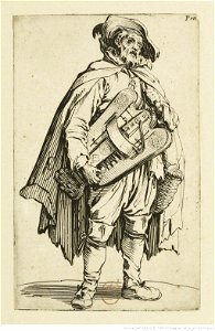
jacques callot - les gueux in the bibliothèque nationale de france
jacques callot
8501 - 8600 of 9,486
Next page
/ 95